
Here is a question: How can you tell what areas of a DEM are lakes and ponds, given no other spatial information?
There are probably a lot of ways to do this, but two that I thought of when approaching this problem are using Slope and Aspect information to extract those areas. (For clarities sake, I am running this experiment on a hilly DEM; your results trying to apply this approach to the Netherlands may vary...)
For a reference to my final estimates, I downloaded the shapefile of all waterbodies to overlay them on my DEM of interest. Then, to improve processing times, I clipped their extent to only the bottom half of the DEM. This is a good test section because it includes a large lake, smaller lakes that are higher in the mountains, and then some waterbodies in the more flat sections to the East.

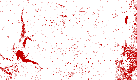
So, the two approaches: Firstly the Aspect approach. Pretty straight forward, I simply ran an aspect process from the Spatial Analyst toolpack, and re-classified it so that any hill without an aspect (meaning it doesnt have a defined ordinal face), will show up red, and all other ordinal directions will be white. Below is the output.
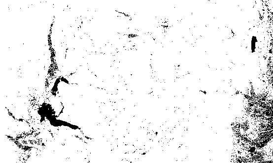
Next, the same process using slope. I ran the slope algorithm from the Spatial Analyst toolpack, then reclassified the output to 2 classes, one with 0 slope (black), and the other to include everything else (white). Below is the output.
Below is the two processes overlaid.

In the overlay, we can see that the aspect approach seems to be more generous with which areas it 'thinks' are water bodies. especially for very small areas.

Here is the aspect approach compared to the known water bodies. We can see that most of the very small areas that it classified are not actually water bodies, but larger lakes seem to be correctly classified. we can also see that areas to the East where the land is flatter have a worse classification accuracy compared to hilly areas. This is no surprise. I expected before that the signal to noise ratio in flat areas would be higher.

Here is the same overlay for the slope classification. Much less noise in this one, although it still had problems in the flatter areas of the DEM to the East of the study area.


Above are some areas with small lakes, as I wanted to see how well the two approaches classified smaller water bodies. (ignore the spatial projection offsets, as the projections between raster and polygon shapefiles were slightly different). I am very pleased with the accuracy here, as the area sizes and even the shapes of the small lakes seem to match quite well. In the future, to increase the accuracy of these approaches, I would run an algorithm to remove any raster areas below a certain size threshold to get rid of most of the noise in the analysis (especially in the more flatter areas). All in all, I think this is a really useful approach to finding and analyzing water bodies using only terrain information.